
Trail Conditions & Safety
Trail Notices
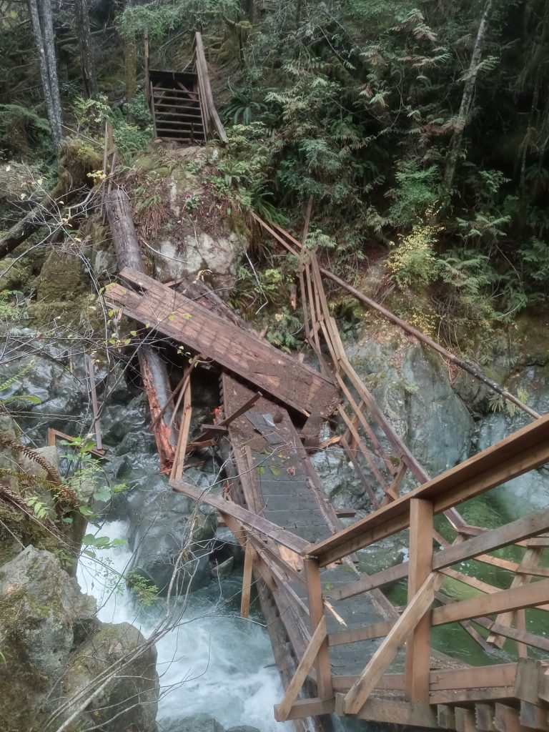
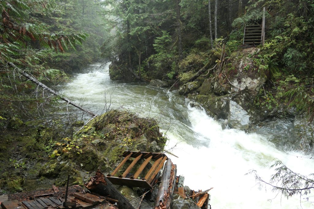
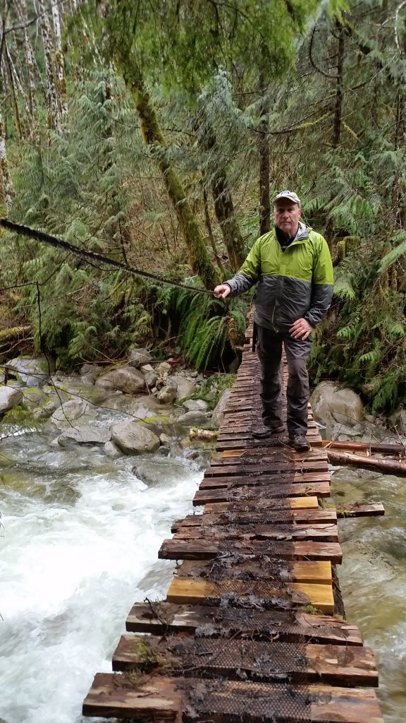
Bridge Closures along Runners Trail – updated February 2024
- The Parsons Creek bridge collapsed and was completely washed away in October 2023. To get between Heather Main and Headquarters Road (HQ Road) hikers must now detour via the Bamfield Main logging road and its old bridge (now closed to traffic) over Parsons Creek.
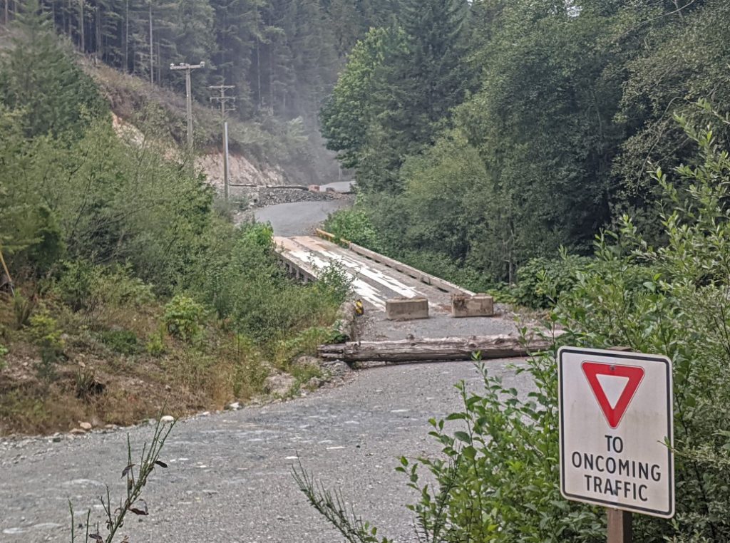
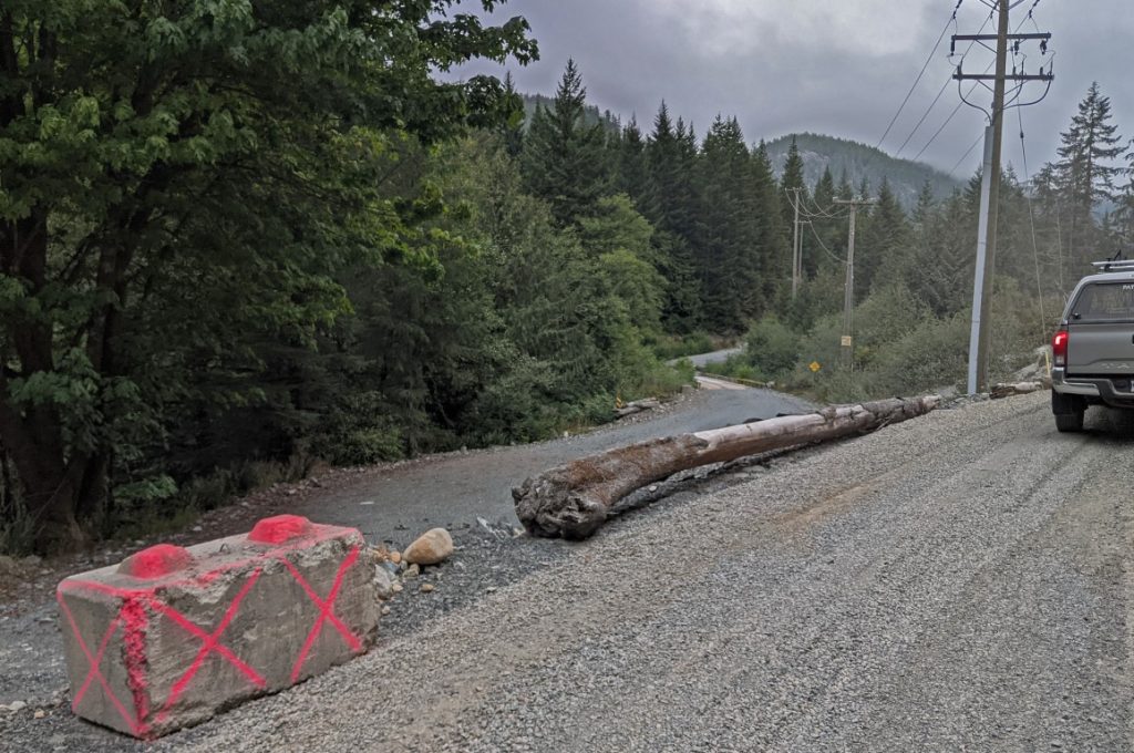
The images below show the detour route over the old Bamfield Main logging road bridge – on left, the approach from the south; on right, from the north (HQ Road).
2. The bridge over the South Fork of Coleman Creek has seriously deteriorated because of its rotting stringers and is no longer safe to use. Detour trails down to and back up from Bamfield Main allow hikers to cross over the creek using the logging road.
Trail conditions – updated Aug 15 2024 (as of end Feb, no info regarding 2025 conditions)
- VIT is in good condition between Victoria and Port Alberni, with the exception of the two bridges noted above (both with short, easy detours).
- The Beaufort Crest trail is now well-marked and has been sporadically cleared/brushed as needed, and also devoid of snow. Maps and gpx tracks do not yet reflect a few relatively minor changes – where discrepancies exist, give priority to the trail marking!
- The climb from the road end up to the Mt. Adrian cell tower is now a defined, marked trail. Past the cell tower hikers must find their own way below and past Mt. Adrian through semi-open rocky and subalpine terrain. Refer to the section “Strathcona Park Boundary-Pearl Lake-Mt. Adrian-Lupin Trails” to download an up-to-date gpx track and read the revised description of the route (this also includes a change to the creek crossing in the side valley) .
- The lower section of Lupin trail , including the old road section has been brushed out. The upper Lupin trail section remains as a route (not defined trail tread) and route marking needs improvement.
- The beach walk section of the Upper Quinsam Lake Trail is accessible, having widened over the dry summer months.
- Brushing of the Upper Quinsam and Wokas trail sections is complete.
- The Gold River Highway Trail section has been restored following recent logging.
- Post-winter trail maintenance has not been undertaken on the Salmon, Grilse, Glen’s, John Fraser, White River and Kokummi Pass trails because of administrative issues – expect sporadic windfall in these sections with some localized serious windfall/snowpress. Between Schoen Lake and Croman Lake, follow the Davie Road throughout; the route along the river is seriously obstructed by windfall/snowpress.
- Woss to the N end of Nimpkish Lake: The ‘Namgis First Nation does not have the capability/personnel available to consider the VI Trail at this time so there is no established trail in this section. Consequently, through-hikers have to determine their own route from just north of Hoomak Lake to Branch NO-2100 – a choice between following the old Englewood rail grade, Nimpkish Main logging road or Hwy 19. If you do hike the old rail grade (suggested option), leave it to follow logging roads to Port McNeill at Branch NO-2100 which starts near to the junction of the rail grade and Nimpkish Main. Expect short sections of thick brush until you hit the old KP2000 road system as we are not be allowed to do maintenance this year.
- Between Port McNeill and the turn-off to the Cluxewe River campsite/resort, follow Hwy 19. A future trail is in the planning stages. Suquash trail sections will not be maintained this year – salal re-growth and sporadic windfall/deadfall can be expected.
- The North Coast Trail is invariably muddy and slippery. Tide tables (Port Hardy) are useful for both here and for the Suquash section.
Safety on the Trail
Users of Vancouver Island Trail do so at their own risk. The Vancouver Island Trail Association (VITA) takes no responsibility for trail user safety. We do recommend that you develop and share a detailed plan of your hike with family and friends. Many hikers use the Adventure Smart app to develop their plans and share with others.
The Vancouver Island Trail passes through a combination of managed forest lands, wilderness areas and rural to urban environments with a corresponding range of trail standards. Trail users are commonly in locations remote from any assistance. The nature of the terrain is highly variable with some steep trail sections and/or poor footing at times. Several larger creeks and rivers are not bridged and so must be forded during lower flows. For safe wading technique, see How to wade across a river.
Many sections of the Trail are suited only to experienced back country hikers. Be sure to research the section of trail you plan to traverse to get a good sense of the difficulty involved and be sure you have adequate skills, experience, strength, and endurance. Users must have adequate navigation skills and appropriate equipment such as maps, compass, GPS and a satellite location beacon. Cell phones are useful for maps, GPS and associated apps, but should not be relied upon for communication because of incomplete cellular coverage. Trail users must ensure they are adequately equipped and supplied for the trip they are embarking on whether a thru-hike or section hike, an overnight excursion, or a day hike.
Trail access cannot always be assured, temporary trail closures and/or re-routing are at times necessary. Trail users should always consult and be familiar with the information provided in the Section descriptions and in the Trail Notices (above). The Trail Notices are particularly important to check for trail closures, trail re-routing and current trail conditions.
Earlier in the year during snowmelt and high flow conditions in streams and rivers, be prepared for sections of flooded trail that may well require bush-whacking to get around. At higher elevations, notably in the Beauforts, Forbidden Plateau and Mt. Adrian sections, navigation is much more difficult when much of the Trail is obscured by snow. In most years, starting a thru-hike from Victoria should not be planned or attempted until after June 15, so that you are into July before reaching the higher elevations. In some years, considerable snow can be encountered well into July.
The Trail route is identified by reflective orange markers attached to trees. However, marking is not completely consistent as it remains a work in progress. Some sections are only marked with flagging tape and other sections are not marked at all.
The Trail passes through the traditional territories of several First Nations and through a wide range of land ownership and Crown land tenures. Users must respect the Land and be considerate of all the various caretakers and managers of the Land. Remember, you are a guest on all lands and should act accordingly. Be sure to leave no trace of your passage and follow all “leave no trace” ethics and procedures.
Campfires are not allowed throughout the length of the Trail. This is critical during the summer hiking season, which usually coincides with periods of high to extreme fire hazard. At higher elevations along the Trail, forest productivity is low and conservation of both live and dead woody material is important to maintain soils, ecosystems and habitats.
Adequate Equipment for Navigation
Since the route of the Trail is not always obvious, hikers must be capable of wilderness navigation and must carry adequate navigational equipment and information.
The wide range of available technology includes GPS units and GPS-capable cell phones, which in combination with the GPS tracks and geo-referenced strip maps available for download on this website are most often used for navigation. Many hikers use Gaia or similar apps on their cell phones. However, hikers should always carry paper maps and a compass since you can never be sure your electronic devices won’t fail for lack of battery power or other issues. In addition, be aware that cell coverage is non-existent along most of the Trail.
It is recommended hikers carry a personal locator beacon (Spot, In Reach, Zoleo) or a satellite phone. Using such devices, hikers should arrange for a regular (at least daily) check-in procedure with family or friends. If plans change, be sure to inform your contacts and have them confirm that they have received and understood the change message.
First Aid Capability
There are numerous first aid courses available specifically tailored to outdoors activities. Once you decide to do outdoor activities in remote areas such as those traversed by Vancouver Island Trail, you would be wise to take a more advanced course tailored to back country conditions.
Safety in Numbers
The extra margin of safety provided by traveling in a group is always advisable in back country areas, although several solo hikers have successfully completed the entire VIT.
Wildlife Encounters and Safety
There are many black bears, cougars, biting insects and things that go bump in the night on Vancouver Island. There is a wealth of available information on this topic including the following:
- https://www.env.gov.bc.ca/bcparks/explore/misc/bears/
- https://www.outdoorvancouver.ca/resources/bears-cougars/
- The Cougar: Beautiful, Wild and Dangerous by Paula Wild, 2013
Safety Around Work Sites
If you encounter an active work site during your hike, such as road maintenance or active logging, the following procedures are mandatory:
- if any equipment is in use such as a road grader, drill, backhoe, excavator, bulldozer etc., stop at a safe distance where the operator can see you. Do not proceed until you have caught the eye of the operator. Only proceed when the operator has seen you and has indicated it is safe to do so.
- if hiking on a road and you encounter a logging truck or other heavy equipment, move well off the tracked portion of the road and make sure the driver has seen you. Continue only when all clear.
- if you encounter a sign warning of ‘BLASTING IN PROGRESS’ follow the procedure above re communicating with the operator. You need to know the blasting signals used just prior to and after a blast. Before a blast, you will hear 12 short whistles (at 1 second intervals), with the blast fired two minutes after the last whistle. If you are close enough to hear this clearly, it’s advisable to stand behind a good-sized tree, some rock can be airborne for several minutes. After a blast and it is safe to proceed, the all clear is sounded – one long whistle lasting 5 seconds.
- if you are down a trail or road and it is blocked by an ‘ACTIVE FALLING’ sign (the sign will typically be on a rope strung across the trail or road), under absolutely no circumstances can you proceed or enter the active falling area. The hiker must stop and wait for the end of the work shift (usually before 3 pm) and for the sign to taken down before proceeding.