
In 2021, Ivan Whitticase, a regular VI Trail volunteer from Port Alberni, hiked sections 1 and 2 of the VI Trail between the Anderson Hill trailhead in Oak Bay Municipality and Port Alberni as a number of day-hikes.
He subsequently compiled a detailed description of this southern part of the VI Trail – the most detailed information available to date, which includes many useful inset maps and images.
Anderson Hill to Port Alberni – 212 km
By Ivan Whitticase
The SE Trailhead of the Vancouver Island Trail is situated in the Municipality of Oak Bay just east of B.C.’s capital city of Victoria.
The trailhead lies on the summit of Anderson Hill, best accessed from the parking area on Island Rd. From there is a nice walk downhill through the park to Transit Rd where you will find a VI-Trail sign on a Centennial Trail signpost. Turn left on Transit Road and then right onto Beach Drive.
Soon after Beach Drive turns sharply away from the shoreline, turn left onto King George Terrace then after a block go right on the north side of the road onto Sunny Lane. You soon should see a narrow trail that heads uphill to the viewpoint on Gonzales Hill (in Walbran Park) – it affords great views to the south and west overlooking Juan de Fuca Strait and the Trial Islands.
Continuing along King George Terrace takes you to Trafalgar Park, with open views of the ocean and trails down to the rocks and a small beach.
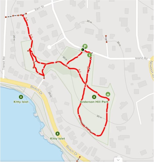
There are several other small parks with access to the shoreline off King George Terrace, which becomes Crescent Road as it curves around Gonzales Bay. Just opposite the intersection with Foul Bay Road you will find another VI-Trail sign attached to a Centennial trail signpost.

Continuing around Gonzales Bay on Crescent Road is a pleasant walk with ocean views. Crescent Road merges into Hollywood Crescent and then becomes Dallas Road at St. Charles St., where you access the new Dallas Road Waterfront Trail which takes you around Ross Bay all the way to and on past Clover Point. The waterfront trail is through green space and provides several access points to the beach via paths and stairs. Here you will meet just about every dog that lives in Victoria – all friendly and having a good time!
Cook Street joins Dallas Road at the start of Beacon Hill Park – a beautiful park with lots to explore including Garry oak meadows here in the driest climate of Vancouver Island. There are restaraunts, pubs, and stores just a short distance up Cook in the area known as Cook Street Village. The VI Trail continues along the Dallas Road Waterfront Trail past Finlayson Point, Steve Fonyo Beach and into Holland Point Park – some nice, secluded beaches along this stretch. Further along you come to the Breakwater Bistro & Bar, opposite a breakwater that shelters the cruise ship docking facilities, with a walkway that takes you all the way out to the lighthouse. Further along you can take a left onto Huron Street which takes you past the Canadian Coastguard Station near Shoal Point at the entrance to Victoria’s Inner Harbor – this street is a dead end, and you must walk back the way you came. At the corner of Dallas and Huron, Fisherman’s Wharf Park is just ahead – yet another good food stop with lots to choose from.

The wharf side road, Erie Street curves left into St. Lawrence Street. As it curves back to the right into Kingston, pick up a trail on your left called David Foster Way along the shoreline and around the headland of Laurel Point. Turn left onto Bellville Street on past the Black Ball/Coho Ferry terminal and in a short distance you reach steps down to the Victoria Inner Harbor Causeway. This takes you past the Parliament Buildings, the Provincial Museum and the Empress Hotel. You can stay on David Foster Way close to the water with its many interests, as far as Yates St. or go right into Victoria’s downtown core via Government or Wharf Streets (MEC at Government & Johnson). Maybe check out the Red Fish Blue Fish take-out café dockside on David Foster Way, famous for its seafood and fish and chips – you will not be disappointed.
From Yates at Wharf Street, access the footpath towards the water that takes you around to and over the Johnson Street Bridge. Take the footbridge over Esquimalt Road and follow the sidewalk alongside Harbor Road past the shipyards. Go onto the ‘Galloping Goose Trail’ where Harbor Road bends sharply left; the ‘Goose’ stays close to the shoreline of the Selkirk Water on your right side, and beneath Bay Street on its approach to Bay Street Bridge. About 750 metres along from the Bay Bridge, the Trail crosses over the Selkirk Water (the “Gorge”) by way of the Selkirk Trestle, and then passes underneath Gorge Road.
You continue heading north along the Goose through urban green space to a foot bridge (the “Switch Bridge”) over Highway 1. Across the footbridge is the junction of the Galloping Goose and the Lochside Regional trails – the VI Trail stays left on the Galloping Goose, heading west. After 2 km, the trail takes you over Mackenzie Avenue near its intersection with Highway 1 with a great view of this complex busy intersection.
The Galloping Goose then parallels Highway 1 and in another 2.2 km passes under Helmcken Road; then an additional 1.2 km after crossing Burnside Road is a very nice coffee shop called The Nest Café. You can’t miss it; it has a sign and entranceway right off the Galloping Goose. Shortly after, the trail passes under Highway 1 and continues as a nice treed rural footpath into Langford, another approximately 7 km.
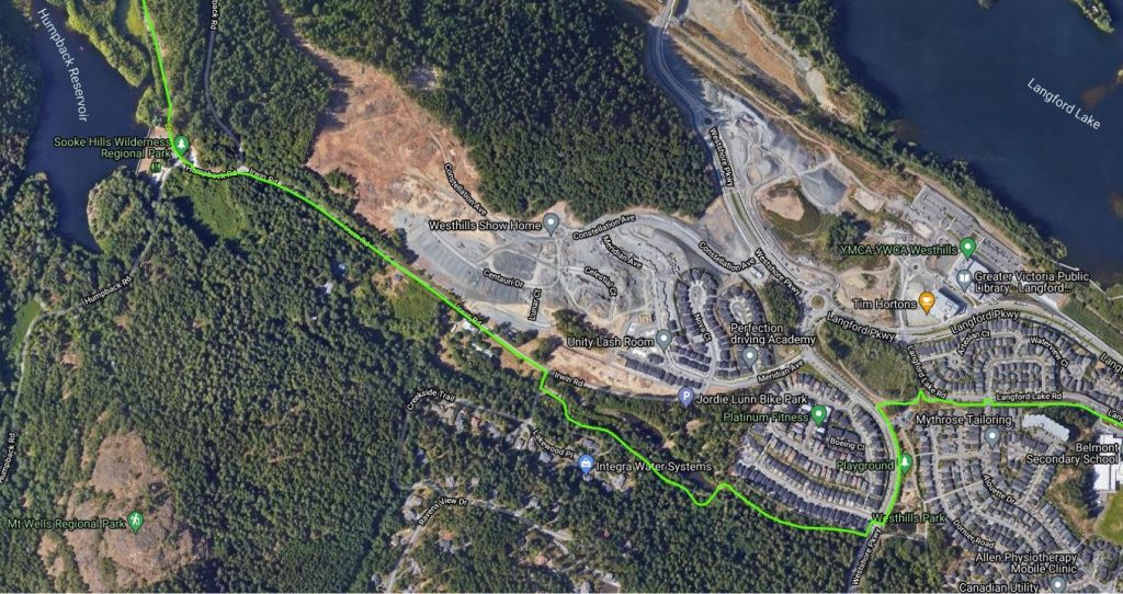
When you reach Veterans Memorial Parkway (Highway 14) you leave the Galloping Goose Trail. At this point cross the parkway and walk along Kelly Road past the West Shore Town Centre shopping mall to Jacklin Road. Cross Jacklin Road and head north for approximately 150 metres, to head west on Rex Road. A short way down on the right side, Rex Road takes you to Hull’s Trail (see map below, zoom in to see details and features). From the end of Hull’s Trail, follow a short section of Glen Lake Road and leave it where is bears sharply left, then via a walkway through Belmont Secondary School (between the parking lot and the athletic field) that continues to the Westshore Parkway – flat apart from one steep switchback.

Go left down a paved trail alongside Westshore Parkway to cross via a marked crosswalk opposite Commander Court. Jog left and down some stairs onto a trail alongside Parkdale Creek (finally into some forest!), past two small lakes in Irwin Park to a road that leads right onto Irwin Road which you follow to the Humpback Reservoir trailhead of the Sooke Hills Wilderness Trail. This trailhead is within Mount Wells Regional Park and the trailhead to the Mount Wells Trail is adjacent.
From the Mount Wells Parking area, the trail heads north to the Goldstream Suspended Bridge, a very pleasant 2.5 km. walk. At the time of writing there is a trail closed sign at Waugh Creek for approximately 200 meters. It is possible to
navigate around this hazard on the trail or on the railway tracks, but take care if work is being carried out to repair this area of unstable slopes. The next feature is the suspended bridge over the Goldstream River. Just above the bridge is the lower service gate to the Victoria Watershed property within the Sooke Hills Wilderness Area.

Heading north from the Goldstream bridge you are essentially climbing up the Malahat by way of the old Niagara Main logging road – up sustained, moderately steep grades (wearing on a hot day!) and passing through second-growth to mature and seemingly remote forests. It is 6.5 km between the upper and lower service gates (no horses are allowed in this section).
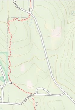
Grades lessen continuing north from the upper service gate for 2.7 km as far as a road named Trail Way. Here you have a choice of routes – crossing the road takes you along a single-track hiking trail through the bush or turning right (west) along the road which will bring you to Goldstream Heights Drive, the route for cyclists. Turn left (north) along this road for 0.7 km and you will re-join the single-track bush trail coming from your left. Cross Goldstream Heights Drive here and continue north on the Sooke Hills Wilderness Trail for 0.5 km to find yourself at a kiosk with information signs for two adjoining regional districts – the Cowichan Valley RD to the north and the Capitol RD to the south. Since Clover Point, the VI-Trail continues to be coincident with the Trans Canada Trail, now on the Cowichan Valley Trail segment. In this area are rocky bluffs and open outcrops you can scramble up for great views looking eastwards. In the next section you pass nearby rural acreage properties where large homes are the norm (perhaps future interface wildfire concerns).
The Trail has now entered the Malahat First Nation traditional territory. It continues from the dual sign kiosk as a wide gravel pathway, as far as the next major intersection at Stebbings Road, a distance of 4.5 km. (Stebbings Road has easy access to Highway 1 via Shawnigan Lake Road). Cross the road to a trailhead and parking lot to continue north. A word of caution for cyclists heading north from this point, beware of several steep short hills with sharp turns in them.

At this point the trail changes and becomes more of a groomed trail, narrower with few straight sections. To the east is young and mature forest, to the west is an avenue of young / mature trees bordering a clearcut which is re-planted and greening up nicely. At 1.2 km north of the Stebbings Road trailhead you are greeted by the very impressive Yos totem pole. The front side is a thunderbird, the back side, a sasquatch. They could not have picked a better setting to display it. This totem pole was carved by Stz’uminus artist John Marston, Nuu-chah-nulth artist Moy Sutherland Jr., and several youths from the Malahat First Nation. The Malahat mountain area is traditionally called “Yos”, hence the name of the pole. Thanks to the Malahat First Nation for allowing us to pass through their lands.
From there you cross Shawnigan Creek and continue along a wide firm aggregate path, downhill for the most part, until you reach the next trailhead at Sooke Lake Road, 2.9 km. North from this trailhead, you travel along and above Shawinigan Lake with unfortunately only a few screened views to the Lake, reaching the Kinsol Trestle at an additional 13 km. There are several access points down to West Shawnigan Lake Road and the lake itself, most notably West Shawnigan Lake Provincial Park. You cross Renfrew Road which has some vehicle parking and then Glen Eagles Road which is the southern parking lot/ access point to the Kinsol Trestle. The Trail passes over the curving, 187-metre long Kinsol Trestle some 44 metres above the Koksilah River – well worth a prolonged visit to explore. Heading north you cross Riverside Road, the north access point and parking for trestle day-trippers.
From the North Kinsol parking to Glenora Trails Head Park is 13.4 km, for the most part flat, with total elevation gain of only 50 meters. After crossing Hume’s and Mountain Roads, the valley opens up with steep hills on either side of farmland. After which you are in mature forest mostly within Cowichan River Provincial Park; closer to Duncan are hobby farms and rural acreages. The last 5 km comprises long straight sections (still old rail grade), but you have time to talk to friendly local people out walking their dogs. When you hike this section, be aware that it is a favorite trail for cyclists, keep to you right all the time as some cycle like in a road race. Glenora Trails Head Park is a very nice with great facilities (water) and trails down to the Cowichan River.
From Glenora Trails Head Park to Lake Cowichan is 23.3 km. There are several riverside single-track paths that leave and re-join the main trail in several locations along the way. BC Parks has also built wooden stairs from and back to the main trail on steep sections. You can find a map of these additional trails at https://www.gaiagps.com/map
The highlights of this section are the old rail trestles, along the CNPR rail line that carried passengers as far as Youbou until 1931 and was carrying logs from Kissinger Lake until 1957. The CNPR was intended to reach Port Alberni, but the project was abandoned in run-up to World War I.


The first trestle you come to is across Holt Creek, next at 64.4-Mile and then at 66-Mile over Marie Canyon. There is a plaque on this trestle that informs you that the molecules of water passing beneath left Lake Cowichan 4 hours and 42 minutes ago! You then come to a parking spot and scenic rest area at Skutz Falls. The last trestle heading west is at 70.2
mile. Then it is a pleasant hike through mature forest on the groomed gravel of the old railbed all the way into the town of Lake Cowichan. Stay on the trail until you reach the Western Terminus of the Trans Canada Trail.

At its most westerly point, the TCT terminus sign and trailhead is located between Wellington Road West and Nelson Road West. From here you can explore the Town of Lake Cowichan or, if you want to pass through quickly, take the road heading west from the terminus for a short distance and turn north on the main road (South Shore Rd.) until you come to a small park on your left called Ohtaki Park. Here you cross a footbridge over the Cowichan River into Riverside Park. Then head a bit up River Road, go left on and follow North Shore Road on past the Lake Cowichan First Nation community and turn left onto Meade Creek Road where North Shore Road turns away from the lake. Meade Creek Road takes you across the Meade Creek bridge; past the bridge on your left are trails leading to and within the Spring Beach Rec Site with its impressive Douglas-fir forest and beach. Turn left to head west when Meade Creek Rd intersects the Youbou Road; it can be busy but does provide good views over Cowichan Lake. Look for a sign to a park called 77-Mile, at this point you can access a road between Youbou Road and the Lake called Creekside Drive; it takes you off the main road for a couple of km, to rejoin the highway just before Lakeview Park. There are several other small parks and public spaces before you reach the town of Youbou some 15.5 km from Lake Cowichan.
Youbou is named after two employees of the Empire Lumber Company which operated the first sawmill there – general manager Mr. Yount and Mr. Bouton, president. The town is small with houses stretching out along the highway for about 4 km. If you want to see Roosevelt elk they are here; go early, they seem to like overnighting in town. Twice we saw a bull munching his way through a resident’s front garden. There are several interesting buildings in town, including the community church. There is also a grocery store, a nice-looking pub restaurant, a gas station and Cassy’s Coffee House (limited open hours – great when open).
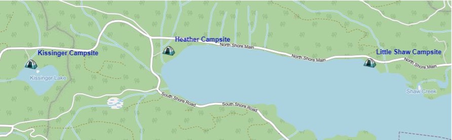
From Youbou westwards to Kissinger Lake past the west end of Cowichan Lake is a further 23 km, on a well-traveled gravel road. This is a busy road, dusty in the summertime, with sections having very limited hard shoulders so it is good to show something bright or reflective. The road walk along North Shore Main gives you several options for camping or maybe an overnight stay at a B&B. For the campsites west of Youbou, it is advisable to book ahead during the summer season as it is very popular with tourists.
Both Maple Grove and Pine Point recreation sites are managed by BC Parks. For information go to; https://www.sitesandtrailsbc.ca/ but you are not able to reserve online for either of these sites. If you want to stay at Pine Point you must register at Maple Grove. Both sites are at lakeside and have a park host.
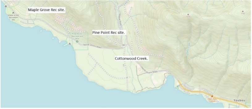
You may be tempted to take what looks like a trail across Cottonwood Creek, but there are private property and no entry signs. Crossing Cottonwood Creek is questionable – you may want to check with locals before going that way. Or, take the road just to be sure. Once you are past Pine Point Rec site the hike becomes more interesting as the road is closer to the lake and more views open up.
Before you reach Shaw Creek, the road goes on the north side of a large hill; mature forest with large maples provides a canopy over the road, nice on a hot day. After crossing Shaw creek, you approach Little Shaw Campsite. Next is Heather campsite, then after back in the forest for a couple of km you approach Kissinger Lake Campsite. This site, as well as Heather and Little Shaw campsites are owned and managed by Mosaic Forest Management. They are open for bookings from March 1st, but friendly campsite hosts at Kissinger have found space for backpackers on short notice in the past.

Kissinger Lake to Nadira 700 is 15.6 km. After leaving Kissinger Lake the trail sections are well marked with 2”x2” fluorescent orange trail markers and colorful 6”x6” Vancouver Island Trail signs at road to trail transitions. From Kissinger Lake head west on North Shore Main for about 300 metres; on your right you will see an old road which is blocked to traffic, now a trail and a short cut to the next road section. Take this for 1.2 km and you come out onto Nitinat Main where you keep heading west for another 2.5 km until you see an old road with a red gate on the west side of the road. This is the route to the Nitinat River crossing (a ford), a distance of 2.3 km (1.7 km of old road; 0.6 km of single-track).

Follow old roads for 1.7 km (ignore a couple of side spurs) where you will find a well-marked, single-track trail on your left taking you through the forest, then down a short steeper pitch to the river crossing. You drop off the trail onto river gravel, then head upstream a short distance to a large open gravel bar. Search the bank on the other side for a trail marker attached to a tree, this is approximately the best place to wade across. To the left of the marker, you will see a dirt gravel ramp in the bank, where ATV’s cross. In the middle of September 2021, the depth of the ford was about 15 inches in places. Another time I made the crossing, the water covered my knees. If you are not familiar with fording a river, search the web for tutorials on how to do this safely.

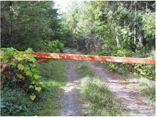
If crossing the Nitinat river is too dangerous, there is an alternate route. Starting at the red gate, continue north on Nitinat Main, see map. Pick up the road labeled BR2 on the west side, follow it to/over the bridge, take the branch left which eventually heads south to where the VI-Trail comes up the hill from the river, crosses the road, and then heads up trail to Parker Ridge. Distance from the red gate, over the bridge around via the west-side road to the trail through forest leading to Parker Ridge is approximately 6 km.
Once you are on the west side of the Nitinat (a great spot to camp), the trail passes through a lush riparian strip of forest (near the river, watch out for the rare Scouler’s corydalis), then across a recent clearcut up to the west side road, and then onto a well-marked trail through scenic mature forest to the top of Parker Ridge. The trail leads onto an old road on the ridge where you meet a thicket of young red alder trees blocking the way; stay on the road and push your way through – only about 30 meters. Then keep following the ridge road ignoring a branch road to the left and two more to the right, thence heading more steeply downhill to join the main logging road which runs along the east side of Tuck Lake.
Keep heading north and soon you will notice a short spur off to your left that goes to Tuck Lake and a small camping area. Continue north; the road curves around a 90-degree turn to the west and you shortly come to a branch road that again heads north (triangular-shaped intersection). Take this northbound road, pass a branch on your right and shortly another on your left and in approximately 200 meters you should find the trail on your left over a mound of gravel that takes you to Nadira Main via Nadira 700. As mentioned before the VI-Trail .gpx track is accurate and if you are using it there should not be a problem navigating this route. Before long, the trail progresses up a very steep hill, then onto an old grown-in road to Nadira 700 where you go right. By this time, you are heading west to follow the road, merging with Nadira Main to head quite steeply downhill (3.9 km on NA-700 and NA-Mn). At the bottom of the long hill, you come to a junction; go left onto Nadira 400 over a Little Nitinat River bridge. Across the bridge and in a short distance uphill you will find the next section of trail on you right. This section roughly parallels the Little Nitinat River along a picturesque trail for 2.3 km to another branch road off Nadira Main. Turn right on the road to cross another bridge back over the Little Nitinat and in approximately 100 m pick up the next trail section on you left. Follow this for 1.1 km and on your way watch for some deep pools in the river, notably the lovely ‘Emerald Pool’ (N48 56.817 W124 39.601) with easy access at and well worth the stop (or swim on a hot day). This trail section ends on Nadira Main, where you go left for a 200 m road walk and pick up the next trail section on your right (just before yet another bridge over the Little Nitinat). This is the start of the Runners Trail which traverses around Francis and Darlington Lakes, and then on into the large clearing of the former Franklin Logging Camp. The trail around Francis Lake goes through some reserved old-growth forest of a deer winter range. The trail skirts a cutblock logged in 2020 on the north side of Darlington Lake. Continue past Darlington Lake and in 1.9 km you will find yourself at the old ‘Camp B’ logging camp, commonly know as ‘Franklin Camp’. Cross this large open area via an old road through the former “married quarters” with some still-thriving, introduced species of trees and garden plants, and pick up the trail which crosses Coleman Creek on an old bridge (refer to the map).
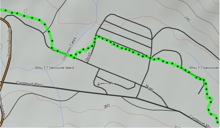
In a short distance the trail crosses North Coleman Main and another km puts you on an old grade just above the main road between Alberni and Bamfield. When the trail intersects a fairly recent spur road just above Bamfield Main, go right on this spur road, staying straight where it bends uphill to the right and you quickly come to a creek with a collapsing culvert. The old grade becomes increasing grown-in for a stretch before you are back on single-track trail. In under 1 km you will cross a creek on a bridge with a rope ‘handrail’, known as the ‘40-foot bridge’, flanked by short steep climbs on both sides of South Coleman Creek. The next 7 km of mostly old grade takes you to Heather Creek Bridge with a ladder on the far side; once over the top you go down hill through a recent clearcut/plantation. Turn right on the road which takes you in a very short distance to Heather Main, turn left and when you come to the main Franklin River Road you should see on the far side a VI-Trail logo on a steel pole. This puts you back on trail to cross Parsons Creek by way of an impressive bridge and on up to the Headquarters Bay Road. To continue north; stay on this road. There are sections of trail adjacent to HQ Road, but it has fallen into disuse and much of it is no longer navigable due to windfalls. Headquarters Road (another section of old rail grade converted to road) is a very pleasant, narrow, shaded road walk with little traffic. If you walk on the left side of the road there are good views of the forest and valley below. The road ends at a turn around point and there you pick up the trail/old, mossy rail grade which is the start of Stage 3 of the Alberni Inlet Trail.

Stage 3 is mostly flat, grown-in railbed but punctuated by 8-9 steep-sided gully crossings where old railway trestle crossings have collapsed other than remnants of impressive timber work. The first of these crossing involves a substantial diversion away from the old rail-grade to cross over Chesnucknuw Creek on a temporary bridge.
Be aware that at the north end of Stage 3 you reach the Franklin River where the old bridge collapsed a few years ago – hence you must ford the river. It’s best to check the state of the Franklin River before proceeding along this section – has there been much rain and/or snowmelt up higher in the last several days? If you hike as far as the Franklin River and cannot cross the river, the logging road walk to the Stage 2 trailhead kiosk involves an approximately 28 km detour by way of Lizard Pond, Hawthorne Main, the Franklin River Road, and Bell’s Bay Road.
Information for Stage 3 on the VI-Trail web site is not currently available, but the trail is well marked with interesting viewpoints, several old rotting trestles and short side trails to beaches to visit along the way. There are several creek crossings, and the trail is well maintained.
Stages 2 and 1 are most enjoyable hikes (moderate to difficult) with expansive view over Alberni Inlet. There is plenty of information on the VI-Trail web site about these two sections.; and maps, brochures, and lots of information are also available at: https://www.acrd.bc.ca/alberni-inlet-trail.
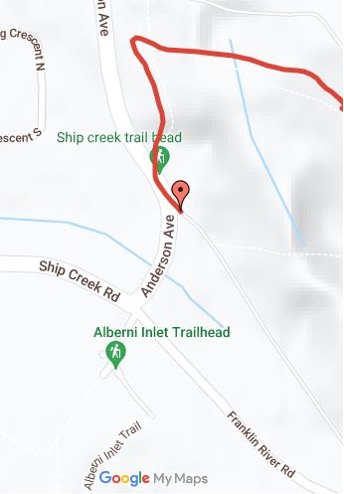
The north trailhead of Stage 1 is at the Alberni Inlet Trail Head parking lot – lots of room here for vehicles etc. – on Ship Creek Road. From here cross Ship Creek Road, walk a short distance along Anderson Ave. and pick up the Ship Creek Trail (red) on your right. It proceeds up a fairly steep hill making a sharp right turn and at the top of the hill and then makes a sharp left turn where you will notice other trails branching off to both the right and left – ‘Fir Baby’, ‘Indecision’ etc. Here, stay on the main trail which proceeds in a northerly direction. In 2.1 km you drop down onto the Maquinna trail, also know as the APL grade; turn right along this trail and in another 600 meters the trail divides. Keep left on the main trail (see map, Wrong Way). After this junction you are on the Argyle Street section which crosses over the east end of Argyle Street and continues for another 300 meters where it makes a sharp left turn and becomes the Dry Creek Trail. In approximately 400 meters it makes a sharp right turn heading downhill to Owatchet Creek (aka Dry Creek).

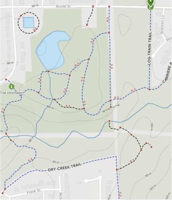
Continuing downhill and across the bridge, head uphill to Burde Street and the start of the Log Train Trail. Due to the many trails in this area (some seasonal), a map is provided. If you wish to find out more regarding the trails in this area, the All-Trails app is a useful source of information. If you are following the VI Trail gpx tracks, you should not have any problems.
Crossing Burde Street you will see a trailhead sign, a yellow gate and room to park a couple of vehicles – this is the start of the Log Train Trail. Information on this historic old rail bed / trail can be found at: https://www.acrd.bc.ca/log-train-trail. Proceeding northwards, stay on the main trail which in 2km takes you down to Roger Creek where you will see a bridge. Cross here and continue for another 1.2 km. and you find yourself at Redford Street/the Port Alberni Highway. Cross and continue north on Maebelle Road for a short distance to cross Johnston Road/Highway 4. Continue north on Maebelle for another 700 m to a right-angle turn onto Mozart Road.
If you want access points to food, lodging etc. in Port Alberni, you can head west on Argyle Street to 10th Avenue. Here just south on 10th you will find a Quality Foods for groceries, drug store and coffee shop – 1.1 km from the trail. The next exit point is Burde Street: here again head west to 10th, then north on 10th to Redford Street where a Save-On-Foods, Shoppers Drugs, and fast food are available – also 1.1 km from the trail. The third and the last chance for shopping is Highway #4 (Johnston Road): again, head west and downhill for 1.6 km to the town’s main shopping centre with Walmart, Canadian Tire, ‘No Frills’ food store, and several fast-food establishments, including a Boston Pizza. Redford Street and Highway #4 (Johnston) both have several motels if you want to take a break with a comfortable bed in Port Alberni.
At the Maebelle-Mozart junction, turn right onto a trail and follow it until you meet the Log Train Trail/old rail grade. Turn left which heads you in a northwest direction along the main LTT. At 2km you cross the Cold Creek bridge, where you can take a short side trip to Cold Creek Falls over massive conglomerate rock, which can be quite spectacular after heavy rain or snow melt. Continue for another 1.5 km and the trail is interrupted for a short distance (a 600 m gap) at the junction of Horne Lake and Tahlen Roads. Head along Tahlen to Desmond Road then to the end of Desmond where you pass through a yellow gate, back onto the Log Train Trail.
Another 3km along the LTT you will see a sign indicating the McLean Mill National Historic Site to the southwest with its extensive collection of old logging and sawmilling equipment. The sign also indicates access northeast to the Beaufort Range, by following/climbing a rough trail up to railway tracks; crossing the tracks and following the trail up hill for about 450 meters to a junction where the trail turns sharp right; straight ahead is a dead end. This places you on a main logging road on which you head northwest to Don’s Trail, and the northwest peak of Mount Irwin. The maps and .gpx tracks on the VI-Trail web site are the best means of navigating this maze of old roads and beyond.

Happy Hiking!